云的 10 种基本类型及其形态
The 10 Basic Types of Clouds
Also learn what weather's coming based on the cloud type
By Tiffany Means
 ThoughtCo / Vin Ganapathy
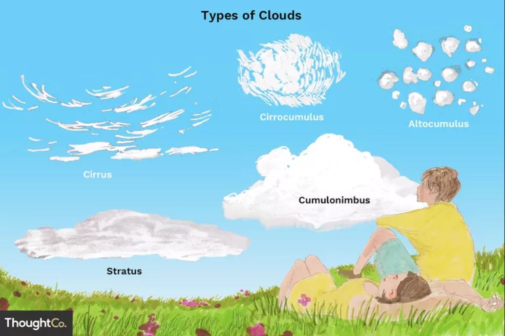
According to the World Meteorological Organization's International Cloud Atlas, more than 100 types of clouds exist. The many variations, however, can be grouped into one of 10 basic types depending on their general shape and height in the sky. Thus, the 10 types are:
- Low-level clouds (cumulus, stratus, stratocumulus) that lie below 6,500 feet (1,981 m)
- Middle clouds (altocumulus, nimbostratus, altostratus) that form between 6,500 and 20,000 feet (1981–6,096 m)
- High-level clouds (cirrus, cirrocumulus, cirrostratus) that form above 20,000 feet (6,096 m)
- Cumulonimbus, which tower across the low, middle, and upper atmosphere
Whether you're interested in cloud watching or are just curious to know what clouds are overhead, read on to find out how to recognize them and what type of weather you can expect from each.
01 Cumulus
 DENNISAXER Photography/Getty Images
Cumulus clouds are the clouds you learned to draw at an early age and that serve as the symbol of all clouds (much like the snowflake symbolizes winter). Their tops are rounded, puffy, and a brilliant white when sunlit, while their bottoms are flat and relatively dark.
When You'll See Them
Cumulus clouds develop on clear, sunny days when the sun heats the ground directly below (diurnal convection). This is where they get their nickname of "fair weather" clouds. They appear in the late morning, grow, and then disappear toward evening.
02 Stratus
 Matthew Levine/Getty Images
Stratus clouds hang low in the sky as a flat, featureless, uniform layer of grayish cloud. They resemble fog that hugs the horizon (instead of the ground).
When You'll See Them
Stratus clouds are seen on dreary, overcast days and are associated with light mist or drizzle.
03 Stratocumulus
 Danita Delimont/Getty Images
If you took an imaginary knife and spread cumulus clouds together across the sky but not into a smooth layer (like stratus), you'd get stratocumulus—these are low, puffy, grayish or whitish clouds that occur in patches with blue sky visible in between. When viewed from underneath, stratocumulus have a dark, honeycomb appearance.
When You'll See Them
You're likely to see stratocumulus on mostly cloudy days. They form when there's weak convection in the atmosphere.
04 Altocumulus
 Seth Joel/Getty Images
Altocumulus clouds are the most common clouds in the middle atmosphere. You'll recognize them as white or gray patches that dot the sky in large, rounded masses or clouds that are aligned in parallel bands. They look like the wool of sheep or scales of mackerel fish—hence their nicknames "sheep backs" and "mackerel skies."
Telling Altocumulus and Stratocumulus Apart
Altocumulus and stratocumulus are often mistaken. Besides altocumulus being higher up in the sky, another way to tell them apart is by the size of their individual cloud mounds. Place your hand up to the sky and in the direction of the cloud; if the mound is the size of your thumb, it's altocumulus. (If it's closer to fist-size, it's probably stratocumulus.)
When You'll See Them
Altocumulus are often spotted on warm and humid mornings, especially during summer. They can signal thunderstorms to come later in the day. You may also see them out ahead of cold fronts, in which case they signal the onset of cooler temperatures.
05 Nimbostratus
 Charlotte Benvie/Getty Images
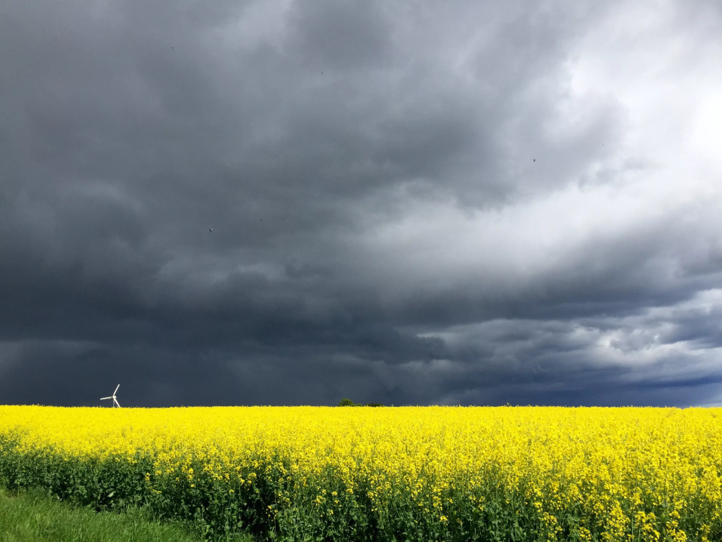
Nimbostratus clouds cover the sky in a dark gray layer. They can extend from the low and middle layers of the atmosphere and are thick enough to blot out the sun.
When You'll See Them
Nimbostratus are the quintessential rain cloud. You'll see them whenever steady rain or snow is falling (or is forecast to fall) over a widespread area.
06 Altostratus
 Peter Essick/Getty Images
Altostratus appear as gray or bluish-gray sheets of cloud that partially or totally cover the sky at mid-levels. Even though they cover the sky, you can typically still see the sun as a dimly lit disk behind them, but not enough light shines through to cast shadows on the ground.
When You'll See Them
Altostratus tend to form ahead of a warm or occluded front. They can also occur together with cumulus at a cold front.
07 Cirrus
 Westend61/Getty Images
Like their name suggests (which is Latin for "curl of hair"), cirrus are thin, white, wispy strands of clouds that streak across the sky. Because cirrus clouds appear above 20,000 feet (6,096 m)—an altitude where low temperatures and low water vapor exist—they are made up of tiny ice crystals rather than water droplets.
When You'll See Them
Cirrus typically occur in fair weather. They can also form out ahead of warm fronts and large-scale storms like nor'easters and tropical cyclones, so seeing them can also indicate storms may be coming.
NASA's Earthdata site quotes a proverb that sailors learned to warn them of coming rainy weather, “Mares’ tails (cirrus) and mackerel scales (altocumulus) make lofty ships to carry low sails.”
08 Cirrocumulus
 Kazuko Kimizuka/Getty Images
Cirrocumulus clouds are small, white patches of clouds often arranged in rows that live at high altitudes and are made of ice crystals. Called "cloudlets," the individual cloud mounds of cirrocumulus are much smaller than that of altocumulus and stratocumulus and often look like grains.
When You'll See Them
Cirrocumulus clouds are rare and relatively short-lived, but you'll see them in winter or when it's cold but fair.
09 Cirrostratus
 Cultura RM/Getty Images
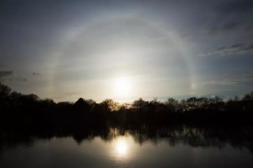
Cirrostratus clouds are transparent, whitish clouds that veil or cover nearly the entire sky. A dead giveaway to distinguishing cirrostratus is to look for a "halo" (a ring or circle of light) around the sun or moon. The halo is formed by the refraction of the light on the ice crystals in the clouds, similarly to how sundogs form but in an entire circle rather than just on either side of the sun.
When You'll See Them
Cirrostratus indicate that a large amount of moisture is present in the upper atmosphere. They're also generally associated with approaching warm fronts.
10 Cumulonimbus
 Andrew Peacock/Getty Images
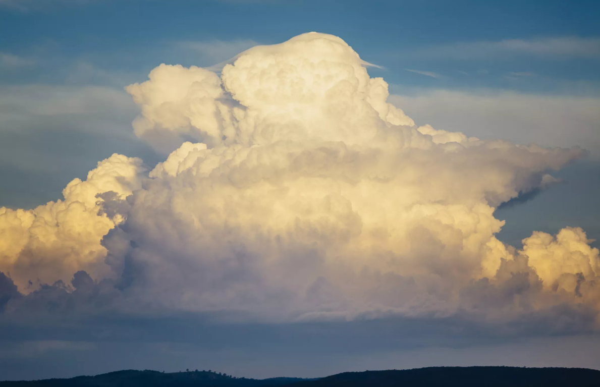
Cumulonimbus clouds are one of the few clouds that span the low, middle, and high layers. They resemble the cumulus clouds from which they grow, except they rise into towers with bulging upper portions that look like cauliflower. Cumulonimbus cloud tops are usually always flattened in the shape of an anvil or plume. Their bottoms are often hazy and dark.
When You'll See Them
Cumulonimbus clouds are thunderstorm clouds, so if you see one you can be sure there's a nearby threat of severe weather (short but heavy periods of rainfall, hail, and possibly even tornadoes).